

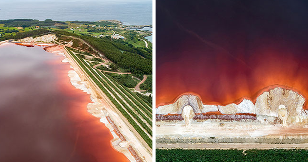
Aerial photography er becomes a tiny punctuation mark at the end of a very sandy sentence.
However, simply putting a camera in the sky does not guarantee an interesting photograph. Altitude provides access, but perspective creates the story. A difference of 30 feet, a slight change in camera angle, or a few steps to the side before takeoff can completely alter the relationship between subjects.
To demonstrate the importance of perspective in aerial photography, I compared 20 common scenes from different heights, angles, directions, and distances. Each comparison reveals how viewpoint affects scale, depth, visual rhythm, emotion, and meaning. The location may remain exactly the same, yet the photograph can become almost unrecognizable.
Why Perspective Matters More Than Altitude
People often assume aerial photography is mainly about flying high. In practice, the most effective drone photography frequently happens at moderate or even low altitudes. Flying higher includes more of the landscape, but it also makes individual subjects smaller and may remove the visual anchor that helps viewers understand what they are seeing.
Camera direction matters just as much. A straight-down view compresses depth and transforms buildings, roads, fields, and shorelines into graphic shapes. An angled view preserves the horizon and reveals layers, elevation, and distance. Neither approach is automatically better. They simply tell different stories.
Scale also changes with viewpoint. In technical aerial imagery, scale describes the relationship between a distance in the photograph and its real-world equivalent. In creative photography, scale is often communicated through familiar objects such as people, vehicles, trees, or houses. Without those references, a muddy shoreline might look like marble, and a small drainage channel might impersonate the Grand Canyon with impressive confidence.
20 Aerial Photography Comparisons That Change the Story
1. Straight Down vs. Angled Across a Beach
From directly overhead, a beach becomes a minimalist study of color and texture. Water, foam, sand, and umbrellas form clean bands and repeating dots. From an angled perspective, the same beach gains depth, waves, distant buildings, and a visible horizon. The first image feels abstract; the second feels like a destination.
2. Low Altitude vs. High Altitude Over a Forest
At low altitude, individual treetops become recognizable characters. Their shapes, gaps, and shadows create texture. At higher altitude, those personalities merge into one enormous green surface. The lower image celebrates details, while the higher image emphasizes the scale and continuity of the ecosystem.
3. Road With a Vehicle vs. Road Without One
A winding road photographed alone may look elegant but dimensionless. Add one small vehicle, and the viewer suddenly understands the road’s width, the surrounding landscape’s size, and the journey being suggested. A familiar object provides scale while also introducing a narrative: Who is driving, and why did they ignore the sensible route?
4. Midday Light vs. Late-Afternoon Light
At midday, overhead sunlight reduces shadows and makes colors appear direct and graphic. Later in the day, long shadows reveal ridges, buildings, trees, and changes in elevation. The location has not moved, but its personality has. One version looks informational; the other feels dramatic and cinematic.
5. Centered Composition vs. Rule-of-Thirds Composition
Centering a lone building can create symmetry, stability, and formality. Moving it toward one-third of the frame creates visual tension and gives the surrounding landscape more importance. The centered version says, “Look at this structure.” The off-center version says, “Look at this structure and the world it occupies.”
6. Wide Landscape vs. Tight Abstract Crop
A wide aerial photograph explains the location. A tighter crop asks the viewer to investigate it. Cropping a salt pond, field, or shoreline can remove recognizable context and emphasize lines, colors, and textures. The image stops behaving like a record and begins acting suspiciously like modern art.
7. River From Above vs. River Toward the Horizon
Photographed straight down, a river becomes a leading line that twists through the frame. Photographed at an angle, it guides the eye toward distant hills or a sunset. The vertical view highlights shape; the angled view creates a sense of movement through space.
8. Symmetrical Building vs. Diagonal Building
Aligning a building squarely with the frame can emphasize architectural order. Rotating the drone or shifting position turns the structure diagonally, adding energy and visual movement. Symmetry feels calm and controlled. A diagonal perspective feels dynamic, even though the building remains stubbornly stationary.
9. Empty Field vs. Field With a Person
A textured field may be beautiful on its own, but placing one person within it changes the emotional impact. The figure introduces scale, vulnerability, and curiosity. A tiny human surrounded by an enormous landscape often communicates solitude more effectively than a close portrait ever could.
10. Shoreline Parallel to the Frame vs. Shoreline Crossing It
When a shoreline runs parallel to an edge, the composition feels organized and peaceful. When it cuts diagonally across the frame, the photograph gains momentum. The second approach often creates stronger separation between land and water while leading the eye from one corner to another.
11. City Block Straight Down vs. City Skyline at an Angle
A top-down city image emphasizes urban planning, roof patterns, intersections, and density. An angled view restores familiar skyscrapers and the horizon. The first perspective asks how the city is organized. The second asks how it feels to standor hoverinside it.
12. Water Reflection Included vs. Reflection Removed
An angled view may capture clouds, buildings, or mountains reflected in water, creating symmetry and depth. Tilting the camera downward can eliminate the reflection and reveal underwater color, sediment, or vegetation. One photograph uses the water as a mirror; the other treats it as a window.
13. Subject Near the Edge vs. Subject Surrounded by Space
Positioning a boat near the edge can imply that it is entering or leaving the scene. Surrounding it with open water creates isolation and calm. Negative space is not empty space; it controls pacing, directs attention, and occasionally gives a tiny kayak an unreasonable amount of emotional responsibility.
14. Camera Facing With the Wind vs. Across the Wind
Wind can change water texture, tree movement, haze, and the drone’s stability. Photographing along the direction of wind may emphasize streaks and movement, while shooting across it can reveal wave patterns and surface contrast. Perspective is not only spatial; it also responds to environmental forces.
15. Short Focal Length vs. Longer Focal Length
A wider lens includes more surroundings and exaggerates the visual difference between near and distant objects. A longer focal length narrows the field of view and can make distant landscape layers appear closer together. The wider image feels expansive; the tighter one feels compressed and deliberate.
16. One Frame vs. Aerial Panorama
A single frame may provide a strong, concentrated composition. A stitched panorama can reveal the full curve of a coastline, mountain range, or urban district. More width is useful only when the additional space contributes information. Otherwise, a panorama is simply a regular photograph wearing a very long scarf.
17. Natural Color vs. Color-Based Abstraction
A realistic edit preserves the location as viewers might remember it. A more interpretive treatment can emphasize complementary colors, subtle tonal divisions, or seasonal contrasts. Editing should support the perspective already present rather than attempting to rescue a composition that never quite arrived at the airport.
18. Landscape Without Foreground vs. Landscape With Foreground
An angled aerial image containing only distant terrain may feel flat. Including a nearby ridge, treetop, rooftop, or rock formation creates layers and improves depth. Foreground elements establish where the viewer is looking from, even when that viewing platform happens to have four propellers.
19. Perfectly Vertical Camera vs. Slightly Tilted Camera
A perfectly vertical camera produces a map-like result, although ordinary aerial photographs may still contain distortion caused by camera tilt and terrain relief. A slight tilt reintroduces visible sides of buildings, slopes, and elevation. The difference may be only a few degrees, but those degrees can completely change spatial perception.
20. Photographing the Landmark vs. Photographing Its Context
A close aerial view makes a landmark the unquestioned subject. Pulling back reveals roads, neighborhoods, terrain, crowds, or environmental pressures around it. The first image documents appearance. The second explains relationships, which is often where the most meaningful visual story begins.
How to Find the Strongest Aerial Perspective
Scout Before Flying
Satellite maps, weather forecasts, sun-position tools, terrain information, and local airspace resources can help identify promising lines and shapes before a battery leaves the bag. Planning does not eliminate discovery. It simply prevents the entire flight from becoming an expensive search for something interesting.
Start Lower Than You Think
Instead of immediately climbing to the maximum permitted altitude, begin low and rise gradually. Pause at different heights to observe how subjects overlap and separate. A scene often reaches its strongest balance before the drone reaches a dramatic altitude.
Rotate Before Relocating
A 90-degree turn can reveal leading lines, reflections, shadows, and visual relationships that were invisible from the original direction. Rotating the drone is faster and more battery-efficient than flying large circles around the location.
Use Familiar Objects to Communicate Scale
Cars, people, livestock, boats, and buildings help viewers understand size. Their position should feel intentional rather than accidental. Waiting a few seconds for a moving subject to enter a useful area of the composition can transform an attractive scene into a memorable photograph.
Respect Safety, Privacy, and Location Restrictions
In the United States, recreational drone pilots generally must keep the aircraft within visual line of sight and remain at or below authorized altitudes, including a maximum of 400 feet in uncontrolled Class G airspace. Controlled airspace may require prior authorization. Many National Park Service locations prohibit launching, landing, or operating drones, and additional state, local, wildlife, property, and temporary flight restrictions may apply.
Rules change, so pilots should verify current requirements before every flight. No photograph is improved by an avoidable citation, a disturbed nesting bird, or a conversation beginning with, “Sir, are you aware this is restricted airspace?”
Field Experiences: What These Comparisons Taught Me
The biggest lesson I learned from making aerial perspective comparisons was that the first composition is rarely the best one. During my early flights, I treated altitude like a magic button. I would launch, climb quickly, point the camera at the landscape, and assume the sky had completed the creative work for me. The results were technically aerial but visually sleepy.
One morning, I photographed a narrow road passing through farmland. From high above, the road looked like a pale thread surrounded by large brown and green rectangles. The pattern was pleasant, but it lacked a focal point. I lowered the drone and waited for a truck to enter the frame. Suddenly, the road had width, the fields had scale, and the image had a story. The truck occupied only a tiny portion of the photograph, yet it became the element that organized everything else.
Another comparison involved a rocky shoreline. My first image was taken straight down. The water formed turquoise shapes between dark rocks, producing an abstract pattern that could have been confused with paint, minerals, or a poorly supervised dessert. I then tilted the camera toward the horizon. The second image showed cliffs, waves, and distant land. It was less mysterious but more immersive. Neither photograph was superior; they served different purposes.
I also learned that small horizontal movements can matter more than large vertical ones. While photographing a bridge, I initially centered it perfectly. The result was balanced but predictable. After moving sideways, the bridge aligned with a curved road and a patch of sunlight. The new perspective connected three separate elements into one visual path. I had changed the drone’s position by only a modest distance, but the composition felt completely redesigned.
Light repeatedly proved more important than height. A top-down image of trees captured near noon looked flat because the canopy received almost uniform illumination. Returning later produced longer shadows between the trees, revealing spacing, height, and terrain. The forest had not changed. The sun had simply begun doing free production design.
Wind created another useful lesson. On a calm day, a lake reflected clouds so clearly that the angled image appeared almost symmetrical. During a breezier visit, the reflection disappeared, but surface ripples created texture that looked especially strong from directly overhead. Conditions that weakened one perspective improved another.
Perhaps the most surprising discovery was how often descending improved the photograph. Higher views were excellent for explaining geography, but lower views created stronger relationships between individual subjects. At moderate altitude, a person walking beside a row of trees remained recognizable while the surrounding pattern was still visible. From much higher up, that person became a nearly invisible pixel with excellent cardio.
These experiences changed how I approach every flight. I no longer ask only, “How high should I go?” I ask whether the camera should face down or forward, whether the scene needs a scale reference, whether the subject should be centered, and what information belongs outside the frame. Perspective is not one decision. It is a sequence of small choices that determines what the viewer notices, understands, and feels.
Conclusion
Aerial photography is powerful because it allows familiar places to be reorganized visually. Height can reveal patterns, but angle reveals relationships. Distance controls scale. Direction controls movement. Light controls depth. Even a tiny person, car, or boat can transform an abstract landscape into a human story.
The most useful habit is to create variations rather than settling for the first impressive view. Fly lower, climb gradually, rotate, tilt the camera, leave negative space, include context, and then compare the results. The best perspective is not necessarily the highest or most unusual one. It is the viewpoint that communicates the idea most clearly.
Note: Flight regulations, airspace restrictions, park policies, privacy rules, and environmental protections vary by location and may change. Always verify current requirements and obtain necessary permissions before conducting aerial photography.