

Note: This article is based on real archaeological research published in Antiquity and reputable science, history, and remote-sensing coverage. It is written as original web content with no copied passages or source-link clutter.
When Spy Satellites Became Archaeologists
During the Cold War, American spy satellites were designed to answer urgent military questions: Where were the missiles? What were rival governments building? Was anything suspicious happening behind closed borders? Decades later, those same satellites are helping answer a very different question: where did the Romans park their forts?
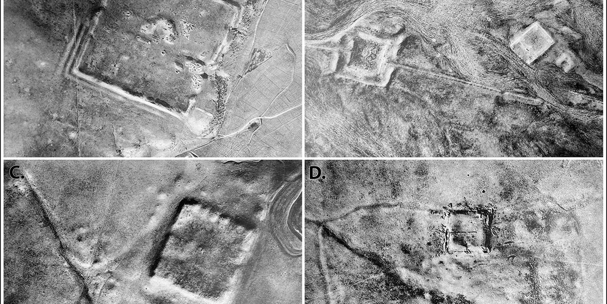
That may sound like the plot of a history documentary written after three cups of coffee, but it is real. Scientists have used declassified Cold War satellite imagery to identify hundreds of previously undocumented Roman forts across the northern Fertile Crescent, especially in areas of modern Syria and Iraq. These were not tiny dots casually circled by an overexcited intern. Researchers documented 396 fort-like structures, many of them square, regular, and large enough to stand out in old black-and-white satellite photographs.
The discovery matters because it changes how scholars understand Rome’s eastern frontier. For nearly a century, many historians pictured the region as a defensive line, a hard edge between the Roman Empire and powers or peoples to the east. The new satellite evidence suggests something more interesting: a wide network of forts that may have supported movement, trade, communication, administration, and military logistics across the steppe. In other words, Rome’s border was not simply a wall. It may have been more like a busy desert highway with checkpoints, warehouses, and a very serious dress code.
The Old Theory: A Roman Wall in the Desert
The story begins long before satellites, with Father Antoine Poidebard, a Jesuit priest, pilot, and pioneering aerial archaeologist. In the 1920s and early 1930s, Poidebard flew over the Near East in a biplane and photographed ancient sites from the air. At the time, aerial archaeology was still a fresh idea. Most archaeologists were used to shovels, notebooks, and sunburns. Poidebard added aircraft to the toolkit.
He documented 116 forts in the region and argued that they formed a broad north-south defensive system along Rome’s eastern frontier. This interpretation fit a familiar image of empire: Romans on one side, enemies on the other, forts standing between them like stern stone bouncers outside an exclusive Mediterranean nightclub.
His work was impressive, especially considering the technology of the era. But there was a catch. Poidebard’s route shaped what he found. Because he flew along certain paths and focused on particular regions, his map reflected not only Roman strategy but also the limits of early aerial survey. Modern researchers call this discovery bias. In plain English, you tend to find things where you look. If you only check the fridge, you may conclude all snacks live near the cheese.
The New Evidence: CORONA and HEXAGON Imagery
The recent breakthrough came from declassified imagery produced by two major U.S. reconnaissance programs: CORONA and HEXAGON. CORONA operated during the early decades of space-based intelligence and collected vast photographic coverage of Earth between 1960 and 1972. HEXAGON, a later and more powerful system, continued the tradition of high-altitude, wide-area surveillance into the 1980s.
These programs were originally built for national security. Their cameras captured military sites, roads, cities, farms, rivers, and landscapes across the globe. The film was physically returned to Earth, processed, and analyzed by intelligence specialists. Eventually, many of these images were declassified and made available through public archives, including the U.S. Geological Survey.
For archaeologists, the timing is priceless. The images preserve landscapes as they looked decades ago, before many areas were altered by modern farming, construction, irrigation, conflict, looting, and urban expansion. In parts of the Middle East, archaeological traces visible in the 1960s may be faint, damaged, or completely gone today. That makes Cold War satellite imagery a kind of accidental time machine. It was built to watch modern armies, but it also captured ancient ones napping under the dust.
How Scientists Found the Roman Forts
The research team, including archaeologists Jesse Casana, David D. Goodman, and Carolin Ferwerda of Dartmouth College, used remote sensing to study a huge area across the northern Fertile Crescent. Their study, published in the peer-reviewed archaeology journal Antiquity, compared historical satellite photographs with known archaeological sites and modern imagery.
The process was not as simple as typing “Roman forts near me” into a search bar. Researchers had to correct and align old images, examine landscape features grid by grid, and identify patterns that matched known Roman or late Roman military architecture. Many of the newly documented structures appear as square or rectangular enclosures, often measuring roughly 50 to 80 meters per side. Some larger fortifications were far more complex, with multiple buildings and walls reaching up to about 200 meters per side.
Because satellite images cannot provide pottery dates, inscriptions, or excavation layers, the researchers were careful in their wording. These are forts or fort-like structures, and many are likely Roman or late Roman based on their shape, location, and comparison with known sites. Some may have been reused in later periods. Archaeology is not a magic trick; it is detective work with dirt, pixels, and patience.
A Fort Network, Not Just a Border Fence
The most important finding is not merely the number of forts. It is their distribution. Instead of confirming Poidebard’s north-south defensive line, the newly mapped sites show a much wider east-west pattern. The forts stretch across the margins of the Syrian steppe, broadly linking the area of Mosul on the Tigris River with western Syria near Aleppo.
This changes the historical picture. A strict defensive frontier would likely form a relatively clear line, especially if its purpose was to block movement from east to west. But a broad network of forts spread across the steppe suggests something more flexible. These structures may have helped Roman authorities manage travel, protect caravans, support soldiers, move supplies, and connect distant settlements.
That does not mean the forts had no military purpose. Rome was not exactly famous for leaving borders unattended with a friendly “good luck, everyone” sign. But the evidence suggests that the eastern frontier may have functioned as a zone of interaction as much as a zone of separation. Soldiers, merchants, officials, local communities, and travelers could all have moved through this landscape. The forts may have been nodes in a living network rather than bricks in a giant imaginary wall.
Why This Discovery Is Important for Roman History
The Roman Empire is often described through its most visible monuments: roads, aqueducts, amphitheaters, and walls. Hadrian’s Wall in Britain, for example, has become a symbol of Roman frontier control. But the eastern frontier was different. It faced powerful states such as the Parthian and Sasanian empires, as well as mobile groups and desert communities. The geography was vast, dry, and difficult to control with a simple barrier.
The newly identified forts suggest that Rome’s eastern strategy relied on mobility and connectivity. A fort could serve many purposes at once. It could house troops, store supplies, protect wells, oversee road traffic, collect information, and signal imperial presence. In a desert environment, even a modest installation could become a crucial point of safety and authority.
This matters because it softens the old image of Rome as a rigid empire obsessed only with defense. The empire certainly defended itself, sometimes aggressively. Yet frontiers were also places of exchange. Goods, languages, customs, technologies, and ideas moved across them. The Roman forts uncovered through satellite archaeology may help scholars understand how imperial power worked on the ground, not as a neat line on a map but as a web of relationships across a complicated landscape.
Satellite Archaeology: The Science of Seeing What Time Tried to Hide
Satellite archaeology uses images captured from above to detect traces of human activity. These traces can include walls, roads, canals, field systems, burial mounds, settlements, and forts. Sometimes features appear because of soil color. Sometimes they show as shadows at low sun angles. In dry landscapes, ancient architecture may leave faint shapes that are nearly invisible from the ground but clear from the sky.
Cold War imagery is especially useful because it predates many modern disturbances. Modern satellite photos are sharper in some ways, but they show the world after decades of development. A site that was visible in 1968 may now sit under a field, road, military zone, reservoir, or neighborhood. The older image becomes the only surviving record of the landscape before transformation.
This is why declassified CORONA and HEXAGON imagery has become a major tool in Middle Eastern archaeology. It helps researchers study places that are hard to access because of conflict, politics, terrain, or preservation risks. It also allows large-scale analysis. Instead of excavating one site at a time, scholars can examine entire regions and ask broader questions about settlement, movement, trade, and environmental change.
What the Forts Look Like from Space
From the ground, an ancient fort may look like a low rise, a scatter of stones, or nothing especially dramatic. From above, however, patterns emerge. A square enclosure stands out against the surrounding desert. A corner tower may reveal itself as a small protrusion. A road may appear as a pale line crossing the landscape. The human eye, trained by archaeological comparison, begins to notice regularity where nature usually prefers messier designs.
Many of the forts identified in the study share similar forms with known Roman military sites. Their shapes are too regular to dismiss as random geology, and their placement makes sense within a network of movement. However, responsible researchers avoid overclaiming. A satellite image can suggest a Roman fort, but excavation, surface survey, ceramics, inscriptions, and historical context provide stronger confirmation.
That caution is part of what makes the discovery credible. The team did not announce that every square mark in the desert was definitely built by a Roman centurion named Marcus who was late for lunch. Instead, they built a case based on pattern, comparison, geography, and the known history of Roman activity in the region.
The Human Side of a Pixelated Discovery
There is something wonderfully ironic about this discovery. Cold War satellites were launched during an age of suspicion, secrecy, and geopolitical tension. Their mission was to watch the present for signs of danger. Yet today, their images help researchers reconstruct a past built on movement, contact, and exchange.
The technology also reminds us that archaeology is not only about spectacular treasures. No golden crown is required. A line of forts in an old satellite image can be just as powerful because it changes the map in scholars’ minds. It forces historians to reconsider assumptions that lasted for generations.
It also highlights the importance of preserving data. Images collected for one purpose can become valuable for another. Military archives become scientific tools. Intelligence photography becomes cultural heritage evidence. A photo once locked away in a classified file can later help protect endangered archaeological landscapes. That is quite a career change for a spy satellite. Most of us only switch jobs; CORONA switched centuries.
Challenges and Limits of the Research
As exciting as the discovery is, it does not answer every question. The exact dates of many forts remain uncertain. Some may have been built during the Roman period and reused later. Others may be similar in shape but belong to different historical contexts. Without excavation, scholars must work with probabilities rather than absolute certainty.
Another challenge is preservation. Some sites visible in Cold War imagery may no longer survive in good condition. Agricultural expansion, construction, looting, erosion, and warfare have transformed many landscapes in Syria and Iraq. Remote sensing can document endangered sites, but it cannot physically protect all of them.
There is also the ethical challenge of studying heritage in conflict-affected regions. Archaeologists must consider local communities, national heritage laws, site security, and the risk of exposing vulnerable locations. Mapping the past is valuable, but responsible publication matters. A beautiful map can help science; in the wrong hands, it can also help looters. The best archaeological work balances discovery with care.
Why Readers Should Care
This story is more than a quirky headline about Roman forts and spy satellites. It shows how modern technology can rewrite ancient history. It proves that archives still hold discoveries waiting to be noticed. It also reminds us that frontiers are rarely simple. They are not just lines where one world ends and another begins. They are places where people meet, negotiate, trade, fight, adapt, and move.
The Roman Empire’s eastern frontier was a living landscape. Its forts were not silent chess pieces frozen on a board. They were part of a system used by real people: soldiers sweating through desert heat, merchants guiding animals across long routes, officials counting supplies, local residents dealing with imperial power, and travelers hoping the next stop had water.
By using Cold War satellite images, scientists have given that landscape new detail. They have turned old military surveillance into a tool for historical imagination. The result is a richer, more human view of Rome: not just marble statues and emperors with dramatic profiles, but roads, forts, logistics, and the daily business of keeping a vast empire connected.
Experience Notes: What This Discovery Feels Like in the Real World
For anyone who has ever opened a satellite map and zoomed in on a random desert, this discovery has a special thrill. At first, the landscape looks empty. Then your eyes adjust. A pale line appears. A square shadow seems too neat to be natural. A mound sits where a road should bend. Suddenly the “empty” desert becomes crowded with questions. That is the magic of satellite archaeology: it trains you to see absence as evidence.
One relatable experience is the feeling of looking at an old family photo and noticing something important in the background years later. Maybe it is a house that no longer exists, a tree that was cut down, or a person standing quietly at the edge of the frame. Cold War satellite images work in a similar way, except the family album belongs to the entire planet. The photographers were not trying to document Roman forts, yet there they were, waiting in the background of history.
Students and history lovers can learn a lot from this discovery. It shows that the past is not always hidden deep underground. Sometimes it is hidden in plain sight, but at the wrong scale. Walk across a site and you may miss the pattern. View it from space and the structure appears. It is like trying to understand a mosaic while standing on one tile. You need distance before the picture makes sense.
There is also a useful lesson for researchers, writers, and curious readers: old data is not dead data. A dusty archive can be as exciting as a new excavation trench. The CORONA and HEXAGON images were products of their time, shaped by Cold War fears and military needs. Yet today they help scholars ask peaceful questions about cultural heritage, ancient mobility, and human settlement. That transformation is almost poetic, though the satellites themselves probably preferred being called “strategic assets” rather than “poetic.”
For travelers who have visited Roman ruins, the discovery adds another layer of wonder. Many famous Roman sites are monumental and easy to admire: theaters, baths, temples, columns, and roads. Frontier forts are quieter. They may not have the glamour of the Colosseum, but they reveal how empire actually functioned. Someone had to move grain, guard routes, repair walls, manage animals, pass messages, and keep order far from Rome. These forts are the infrastructure of imperial life.
The story also encourages humility. For decades, scholars accepted a map shaped by what earlier explorers could see. Then new imagery widened the view and changed the interpretation. That does not make earlier researchers foolish. Poidebard’s work was pioneering. It simply shows that every generation sees with the tools it has. A biplane revealed one pattern. A spy satellite revealed another. Future tools, perhaps artificial intelligence trained on historical imagery, may reveal even more.
Finally, this discovery makes the ancient world feel less remote. A Roman fort in Syria or Iraq, a Cold War satellite built in the United States, and a modern archaeologist at a computer screen are all connected in one story. Different centuries, different motives, same landscape. History is rarely a straight line. Sometimes it is an orbit.
Conclusion
The discovery of hundreds of Roman forts using Cold War spy satellite imagery is a landmark moment for remote sensing archaeology. It shows how declassified intelligence photographs can help scientists recover ancient landscapes that modern development and conflict have damaged or obscured. More importantly, it challenges the old idea that Rome’s eastern frontier was simply a defensive wall in the desert.
The newly mapped forts suggest a more dynamic world of roads, movement, trade, security, and administration. Instead of a hard border, the Roman East may have been a connected zone where soldiers, merchants, officials, and local communities interacted across long distances. Thanks to CORONA and HEXAGON imagery, scientists can now study that world with fresh eyes.
There is a pleasing twist in all of this: machines once designed for secrecy are now helping reveal history. The satellites watched the Cold War, but they accidentally preserved the ancient world. Not bad for cameras that probably never expected to become archaeology professors.