Finding something in three dimensions sounds simple until you actually try to do it indoors. Outdoors, GPS usually plays hero. Inside a warehouse, hospital, factory, stadium, office, or smart home, GPS often turns into that friend who promises to help move furniture and never shows up. That is where ultra-wideband, or UWB, enters the scene.
UWB is one of the most exciting technologies for precise indoor positioning because it is built for accurate ranging. Instead of making a rough guess about where a device might be, UWB measures distance with excellent precision by timing radio signals with astonishing detail. When that ranging data is combined with smart anchor placement, synchronization, and location algorithms, you get something very useful: 3D location and tracking that can follow people, tools, robots, vehicles, packages, and devices in real time.
In plain English, UWB helps systems answer three important questions: Where is it? How far away is it? and Is it moving up, down, left, right, or toward me? That last part is why UWB matters so much in 3D tracking. A flat map is nice. A real spatial understanding of height, distance, and direction is better.
What Is Ultra-Wideband, Exactly?
Ultra-wideband is a radio technology that sends very short pulses across a wide swath of spectrum. Because the signal is so wide and so brief, the system can measure signal travel time very precisely. That precision is the secret sauce. In location systems, tiny timing differences translate into very meaningful distance measurements.
Think of it like this: if Bluetooth and Wi-Fi are good at saying, “Yep, that device is somewhere around here,” UWB is much better at saying, “It is 2.4 meters away, slightly to your right, and a bit higher than your current position.” That is why UWB has become such a big deal for precise finding, secure access, robotics, industrial asset tracking, smart devices, and next-generation indoor positioning systems.
It also helps that UWB tends to perform well in busy radio environments. Indoor spaces are full of reflections, interference, and obstacles. UWB is not immune to all of that chaos, but its signal characteristics make it better suited than many other radio options for separating direct paths from reflected ones. In other words, it has a better chance of figuring out which signal actually came straight from the target instead of bouncing around the room like an over-caffeinated racquetball.
Why UWB Is So Good for 3D Location
Two-dimensional positioning is already useful. It can tell you a tag is in Room 204 or near Dock Door B. But the real world stubbornly insists on having height. In multilevel buildings, tall storage racks, stairwells, parking garages, hospitals, and factories, the vertical dimension matters just as much as X and Y.
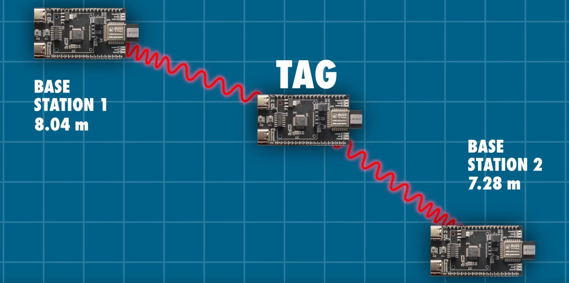
That is where UWB shines. Because it can generate highly accurate distance measurements, it can support 3D positioning when the system is designed properly. Instead of simply estimating a target on a floor plan, a UWB system can calculate spatial coordinates using multiple fixed reference points, usually called anchors, and one moving device, often called a tag.
For true 3D tracking, anchor geometry matters. If all anchors are mounted at the same height, the system may struggle to resolve vertical position accurately. Place anchors at varied heights, and suddenly the Z-axis becomes much clearer. This is the difference between knowing a forklift is in aisle seven and knowing it is lifting a pallet to the third shelf level. One is helpful. The other prevents mistakes, delays, and expensive collisions.
How UWB 3D Tracking Works
1. Anchors Create the Spatial Reference
Anchors are fixed UWB nodes installed in known positions throughout an environment. Their coordinates are surveyed or calibrated into the system. These anchors act like the reference stars in a tiny indoor universe.
2. Tags or Mobile Devices Transmit and Receive Signals
The object being tracked carries a UWB tag or contains a UWB-enabled device. That could be a tool, badge, wearable, robot, smartphone, vehicle key, medical device, or shipping asset.
3. The System Measures Range
Most UWB systems calculate distance using time-of-flight, which measures how long a radio signal takes to travel between nodes. Because the timing is so precise, the range estimate can be very accurate under good conditions.
4. Algorithms Turn Distance Into Position
Once the system has multiple range measurements, it uses trilateration, multilateration, or related algorithms to estimate a location. Add filtering, motion models, and sensor fusion, and the position estimate becomes more stable and more useful for live tracking.
5. Update Rates Keep the Object Moving on Screen
A position once every few minutes is not tracking. It is a polite shrug. Good UWB systems update fast enough to support real-time workflows, which is why they are valuable in logistics, manufacturing, sports analytics, robotics, and secure access.
Main Methods Used in UWB Positioning
Not every UWB system works the same way. Several approaches can be used, depending on the application, budget, power constraints, and desired accuracy.
Time of Flight (ToF)
This is the classic UWB strength. A signal travels between nodes, and the system measures the travel time. Since radio waves move at the speed of light, very small timing differences matter a lot. ToF is widely used because it directly supports accurate ranging.
Two-Way Ranging (TWR)
In TWR, two devices exchange signals and calculate the round-trip travel time. This can reduce the need for extremely tight clock synchronization between all nodes. It is practical and common, especially in many commercial deployments.
Time Difference of Arrival (TDoA)
TDoA systems rely on synchronized anchors that listen for transmissions from a tag. By comparing the arrival times at different anchors, the system estimates the tag’s location. This can scale well for larger real-time location systems with many moving assets.
Angle of Arrival (AoA)
Some UWB systems also estimate direction, not just distance. That can improve locating performance and enable richer spatial interactions, especially in consumer devices and advanced industrial systems.
Where UWB 3D Tracking Is Used
Industrial Asset Tracking
Factories and warehouses love knowing where things are. UWB helps track pallets, carts, forklifts, tools, and work-in-progress inventory with much more precision than coarse location technologies. In 3D environments with tall shelving or multiple levels, that extra spatial detail can save time and reduce errors.
Hospitals and Healthcare Facilities
Medical equipment has a magical ability to vanish exactly when someone urgently needs it. UWB can help track infusion pumps, wheelchairs, beds, and critical devices. Three-dimensional awareness is useful in large facilities where equipment may move across floors, wings, or storage levels.
Smart Access and Vehicle Entry
UWB is increasingly used for secure access because it can verify distance more reliably than older proximity methods. Smart locks, vehicle keys, and phone-as-key systems benefit from precise ranging, which can help reduce relay-attack risks and make access feel seamless instead of awkwardly button-mashy.
Consumer Devices and Nearby Interaction
UWB is now familiar to many people through modern phones, trackers, and wearables. Precision finding experiences use spatial awareness to guide a person to a nearby object or device. This is not just convenient; it teaches consumers to expect location technology that feels directional and immediate rather than vague and fuzzy.
Robotics, Drones, and Autonomous Systems
Indoor robots need reliable positioning when GPS is unavailable. UWB can support robot navigation, fleet coordination, docking, and motion tracking. In hybrid systems, it often works alongside inertial measurement units, cameras, lidar, or vision systems to create a more robust overall navigation stack.
Emergency Response
One of the most compelling UWB use cases is first-responder tracking. In smoke-filled or GPS-denied environments, knowing the location of firefighters or rescue teams can improve coordination and safety. This is not a gimmick use case. It is a potentially life-saving one.
UWB vs. Bluetooth, Wi-Fi, and GPS
Each technology has a lane, and UWB’s lane is precision.
GPS is excellent outdoors over large areas, but weak indoors and not designed for fine indoor 3D tracking.
Wi-Fi is already everywhere and can support positioning, but usually with lower precision for real-time spatial tasks.
Bluetooth is affordable and power-friendly, making it useful for proximity and broad location zones, but it often struggles when you need exact range and direction.
UWB costs more than the cheapest options and may require more careful deployment, but it gives you something valuable in return: far more precise indoor ranging and a better foundation for accurate 3D tracking.
That is why many modern systems use a hybrid strategy. Bluetooth may help devices discover each other. UWB then handles the precise ranging and intent confirmation. It is a bit like Bluetooth saying, “I found your friend,” while UWB says, “Great, they are three steps ahead, one step left, and probably wondering why you walk so slowly.”
The Challenges Nobody Should Pretend Away
Non-Line-of-Sight Conditions
Walls, metal shelving, machinery, people, and other obstacles can distort ranging. If the direct path is blocked, the measurement may be biased. UWB handles multipath better than many alternatives, but physics still gets a vote.
Anchor Placement
A great chip cannot rescue a terrible layout. Poor anchor geometry leads to poor position quality, especially for the vertical dimension. Good deployments pay close attention to anchor spacing, height diversity, and coverage overlap.
Calibration and Commissioning
Real systems need setup. Anchor coordinates must be correct. Time synchronization must behave. Firmware must cooperate. The map must match reality. Skipping calibration is like buying a high-end oven and refusing to preheat it.
Cost and Infrastructure
UWB is powerful, but it is not free. Enterprise-grade deployments require anchors, tags, software, integration work, and ongoing maintenance. The business case is usually strongest where the value of precise location is high.
Power Management
Tags need battery life that fits the workflow. Faster update rates can improve tracking, but they can also drain power more quickly. The right balance depends on whether you are tracking a laptop cart, a worker badge, or a fast-moving robot.
Best Practices for Better 3D Tracking
- Use anchors at different heights to improve Z-axis accuracy.
- Design for line-of-sight where possible, especially in critical zones.
- Test the space with real materials, not just a clean lab diagram.
- Fuse UWB data with inertial sensors, vision, or maps when appropriate.
- Match update rate to the use case instead of chasing maximum speed for bragging rights.
- Plan for maintenance, calibration checks, and software updates from day one.
The Future of UWB Location and Tracking
UWB is moving beyond simple “find my stuff” experiences. The technology is increasingly tied to secure access, spatial computing, robotics, smart vehicles, advanced sensing, and industrial automation. As standards improve and more devices ship with native UWB support, the technology becomes easier to integrate into everyday products and enterprise systems.
That matters because 3D location is becoming infrastructure. It is no longer just a flashy demo. It is turning into a practical layer for software, buildings, logistics, safety, and human-device interaction. The companies that understand this early will design spaces and workflows that are not just connected, but spatially aware.
Conclusion
Using ultra-wideband for 3D location and tracking makes sense when precision matters. UWB gives systems a way to measure distance accurately, locate assets and people in real time, and understand movement in all three dimensions. That opens the door to smarter warehouses, safer industrial sites, better robotics, more secure access control, improved emergency response, and consumer experiences that feel delightfully accurate instead of vaguely hopeful.
It is not magic, and it is definitely not plug-and-pray technology. Good results depend on anchor placement, calibration, radio conditions, and thoughtful system design. But when deployed correctly, UWB is one of the strongest tools available for high-accuracy indoor positioning and tracking. In a world that increasingly cares about where things are right now, not five minutes ago and not “somewhere over there,” that is a very big deal.
Real-World Experience and Deployment Lessons
One of the most useful ways to understand UWB is to look at what teams learn after the demo phase ends and the real deployment begins. On paper, ultra-wideband sounds beautifully clean: install anchors, attach tags, measure distance, and enjoy lovely 3D coordinates. In practice, the experience is still impressive, but it becomes clear very quickly that environment beats theory every single time.
A common early lesson is that ceiling height and anchor placement matter more than newcomers expect. Teams often begin with a neat rectangular anchor layout because it looks organized on a floor plan. Then they discover that the vertical dimension is weak, especially in spaces with mezzanines, ladders, stacked inventory, or multilevel shelving. Once anchors are redistributed across different heights and awkward corners, the tracking quality often improves dramatically. UWB likes geometry. Bad geometry is the silent villain of many indoor-positioning projects.
Another experience repeated across industries is that metal is both useful and annoying. Warehouses are full of it. Factories are full of it. Hospitals have more equipment and infrastructure than many people realize. Metal surfaces can create reflections and complicate measurements, especially when tags are mounted carelessly. Teams that test actual mounting positions on carts, helmets, tools, stretchers, or robots usually outperform teams that assume a tag will behave the same way everywhere. Spoiler: it will not.
There is also the question of what “real time” really means. Decision-makers often ask for the fastest possible updates, as if a tracking system earns bonus points for acting like an espresso machine. But field teams usually learn that the right update rate depends on the job. A slowly moving medical device does not need the same cadence as an autonomous vehicle or sports-tracking system. Better deployments tune update intervals, power usage, and filtering to match the workflow instead of chasing impressive but wasteful numbers.
Integration is another reality check. UWB rarely lives alone for long. In successful systems, it usually joins a cast of supporting technologies: maps, motion sensors, Bluetooth for discovery, cameras, workflow software, access systems, inventory platforms, or mobile apps. The most satisfying deployments are not the ones that simply display dots on a screen. They are the ones that tie location to action. Open the right door. Find the right infusion pump. Confirm the robot reached the correct station. Trigger an alert when a high-value asset leaves a zone. That is when UWB stops being a science project and starts paying rent.
Perhaps the most encouraging real-world lesson is this: users care less about the radio technology than the confidence it creates. They do not want a lecture on pulses, clocks, or multilateration. They want to know where the thing is, whether it is moving, and whether they can trust the answer. When UWB is designed well, people stop thinking about the tracking system itself. They just use it. That is the moment the technology has done its job.